Boston Innovation District
By
BOSTON REDEVELOPMENT AUTHORITY
In
Boston,
USA
No collection found
Are you sure?
This will unsave the project your collection.
Compare
Compare this project with others
Details
Views:
385
Tags
Data Info
Author
BOSTON REDEVELOPMENT AUTHORITY
City
Boston
Country
USA
Year
2012
Program
Waterfront Innovation District
Technical Info
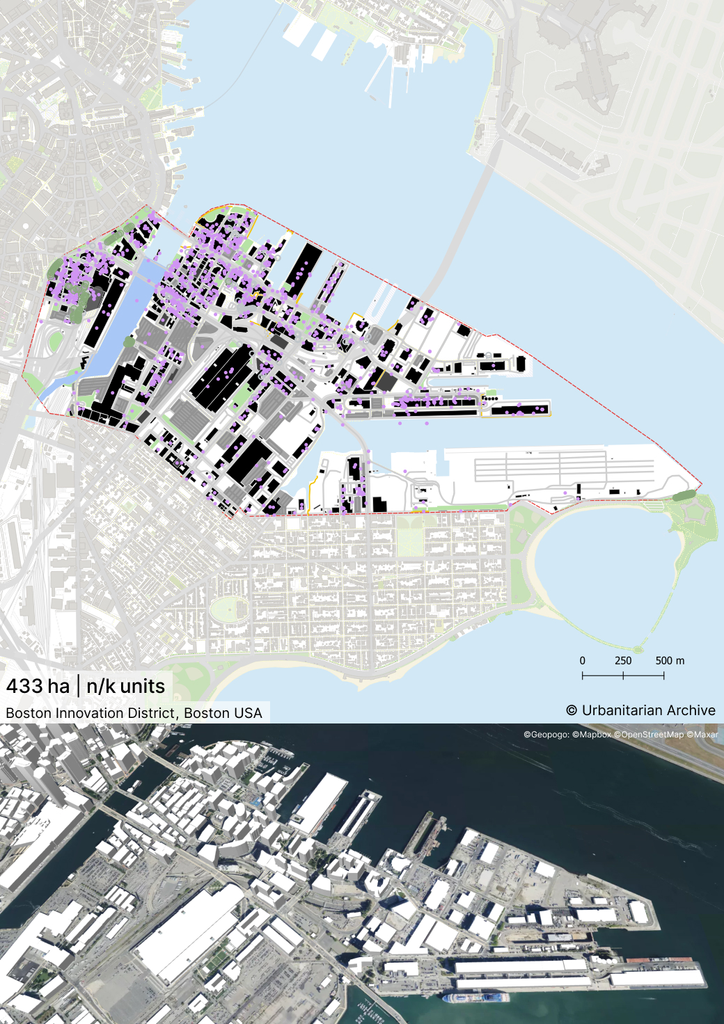
Site area
4338730 sqm
Gfa
0
sqm
Density
0 far
Population density
0
inh/ha
Home Units:
1000
Jobs
0
Streetsroad:
0
%
Buildup:
0
%
NonBuild-up:
0 %
Residential
0 %
Business
0
%
Commercial
0
%
Civic
0
%
Description
- It is a hub of innovation and entrepreneurship, designed as a mixed-use neighbourhood.
- The site was formerly used only for port trade and industrial activities. After these activities decline it was used as an open parking lot before its transformation.
- A portion of the site has been designed as Maritime Industrial Park while the majority of the site hosts residential, corporate buildings and incubators.
- The public spaces aim to create collaborative venues for innovation and enhance access to the waterfront.
- The district would have co-working spaces, entrepreneurial hubs and incubators for start-ups and companies. District Hall is one of the first buildings to be built. It is a public innovation centre.
- Civic amenities like the large convention centre as well as F&B create a vibrant and attractive area for employees and visitors.
- In order to create a 24/7 neighbourhood, substantial amount of housing is being introduced. Different housing types and densities will be created including live-work spaces.
- 40% of the area is being planned as residential area.
- Diverse residential and office programs would be located near transit stops.
- Raymond L Flynn Marine Park is a maritime industrial park located within the district. It undertakes vital manufacturing and other industrial activities in the region.
- The building height would be lowest near the water’s edge and gradually rise as one moves inland. This follows the local character of low-rise waterfront city transitioning into a high-rise business district.
- Building height in the district would be maintained so as to not overpower the neighbouring buildings in the Downtown. The Downtown is Boston’s primary business district.
- The large industrial scale urban blocks are being made into small scale irregular blocks. There would be a flexible parcelling system.
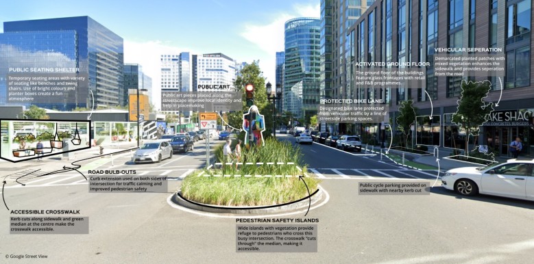
- The streets would acquire a fine-grained grid pattern. The fine-grained nature would allow for amenities and facilities at street level.
- Three main streets running in the East-West direction would act as corridors. They would have retail, commercial, civic functions. Each would have a unique character. They would have different Right-of way dimensions and would be lined with pedestrian sidewalks and promenades. - The North-South streets would be designed as smaller scaled neighbourhood streets. They would connect the inland residential areas with the waterfront. They would terminate at a public space along the water’s edge.
- The E-W and N-S roads form the main roads running through the district. They also feature pedestrian ways.
- The Harborwalk is an important pedestrian route running along water’s edge.
- The water transportation network is also being developed in the form of ferries.
- Linkages would be created between the land and water transport networks. Public transport stops would be located near water transit stops.
- A system of secondary streets would be developed within the blocks to improve connectivity. Creation of Public Spaces
- The Harborwalk is a promenade running along the water edge. It is a lively public space with lighting, landscaping, fishing piers, observation decks and other public facilities.
- The open spaces in the district would be designed as sequential small-scale areas.
- The water is extended inland through the creation of linear parks, pedestrian ways and view corridors.
- The facades of buildings would have pedestrian scaled treatment for storefronts. Ground floors would be visually permeable.
- Consistent cornice lines would be maintained through building heights in public spaces.
- On account of the constant tropical storms occurring in Boston, provision for covered pedestrian ways and enclosed public corridors within buildings are provided. They would also act as through-block connections.
- New buildings would be designed to cut harsh winter winds. These areas would be well-planted. They would act as active public space alternatives to the waterfront during winter months.
- In open areas, trees would be planted as barriers for harsh winter winds in the area.
- The district would provide opportunities for creatives an start-up to develop new technologies through its incubating and co-working facilities.
- Smart technologies would be used to implement clean energy systems, transport and enhance citizen engagement.
Land Use
Urban Structure
Mobility
Living Lab
Location map
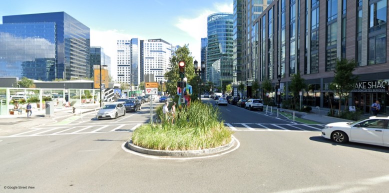
Streetscapes
Explore the streetscapes related to this project.
|
Resources
-
https://www.bc.edu/bc-web/bcnews/nation-world-society/business-and-management/corcoran-center-innovation-district.html
-
https://www.bostonplans.org/getattachment/e0c6d2b9-f1c6-46cb-b5d9-334c91b354fc
-
https://www.bostonplans.org/getattachment/390ef8dd-6269-4096-bb48-ed91f3d3ca03
-
https://www.bostonplans.org/getattachment/6add3767-6eb3-4a06-9d2d-03dd960391ad
-
https://ec.europa.eu/regional_policy/rest/cms/upload/04102019_041442_EWRC2019_09WS543_TRILLO_Boston%20PIE.pdf
-
https://web.archive.org/web/20150221083245/http://www.innovationdistrict.org/the-strategy/
Explore more Masterplans