Saubadia
By
CANCELLOTTI, MONTUORI, PICCINATO, SCALZELLI
In
Saubadia,
Italy
No collection found
Are you sure?
This will unsave the project your collection.
Compare
Compare this project with others
Details
Views:
416
Tags
Data Info
Author
CANCELLOTTI, MONTUORI, PICCINATO, SCALZELLI
City
Saubadia
Country
Italy
Year
1934
Program
New Town
Technical Info
Site area
1400000 sqm
Gfa
0
sqm
Density
0 far
Population density
5000
inh/ha
Home Units:
0
Jobs
0
Streetsroad:
0
%
Buildup:
0
%
NonBuild-up:
0 %
Residential
0 %
Business
0
%
Commercial
0
%
Civic
0
%
Description
- Saubadia was one of many New Towns built before WWII by the Italian Fascist regime(led by Mussolini).
- Several New Towns were built on reclaimed land of the Pontine Marshes located along the Italian Coastline. The previously inaccessible and mosquito-ridden marshes were drained and were developed as independent agrarian New Towns.
- The main principles along which these towns were built was the agricultural activity on reclaimed land, reducing unemployment ,reviving rural communities of Italy and generating support for the Fascist regime(prevalent in the region at the time).
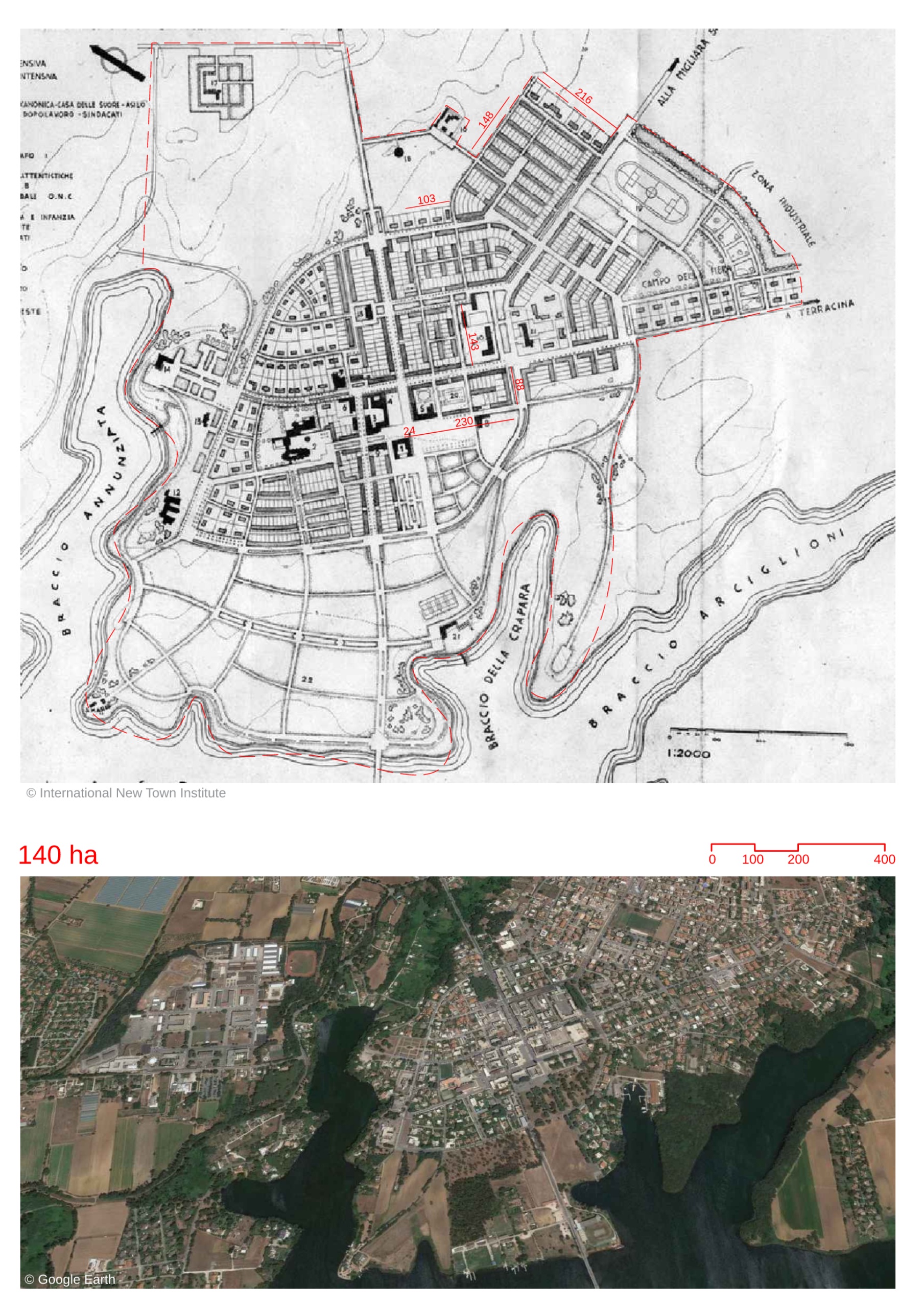
- The Piccinato masterplan for the region envisaged Saubadia as an agricultural centre.
- It was conceptualized as an open city which would bring in the surrounding landscapes through physical and visual connections.
- The Circeo National Park was established to protect the existing natural features and to promote it as a tourism location.
- The city center follows a rationalist layout in the form of four defined quadrants.It was inspired by the traditional Roman town layouts.The quadrants created clear demarcated areas for administrative , religious and economic programs in the town.
- Civic and commercial spaces are concentrated around a central plaza in the town center.
- The plan has three types of open spaces - squares, axes and large green spaces.
- There are three public squares, most prominent being the municipality square at the center.
- Several tree-lined roads form the axes.They connect the squares.
- Large plots of green spaces were maintained as unplanned and open areas, near the adjacent Paola Lake.
- At the intersection of two perpendicular main axes roads lies the municipality square.These roads and the square are wide and of larger scale, possibly planned as spaces for parades and processions of the regime.
- The locality was primarily low-rise.Only administrative buildings used by the regime were allowed to have a higher number of floors.This was the regime’s symbolic way of showcasing control and power, through the imposing state structures.
- The architecture of the region has a style that has both modernist as well as classical influences.This was an attempt to create a unique identity and style in the New Towns of Italy.
Location map
Explore more Masterplans