No collection found
Are you sure?
This will unsave the project your collection.
- Jinwar is an independent community that is only inhabited by women and their children in Northern Syria. Most of the residents are survivors of abusive families or widows of soldiers.
- The idea of this women-only village arose in response to the ongoing Syrian civil war and the subsequent attacks against women living amidst the war. There are several progressive women’s groups who are fighting against patriarchal norms in war-torn Syria. They have heavily influenced the creation of Jinwar, a refuge by women for women.
- Located in an autonomous region of Syria called Rojava, Jinwar showcases how democratic matriarchal societies can empower women and encourage peaceful independent living.
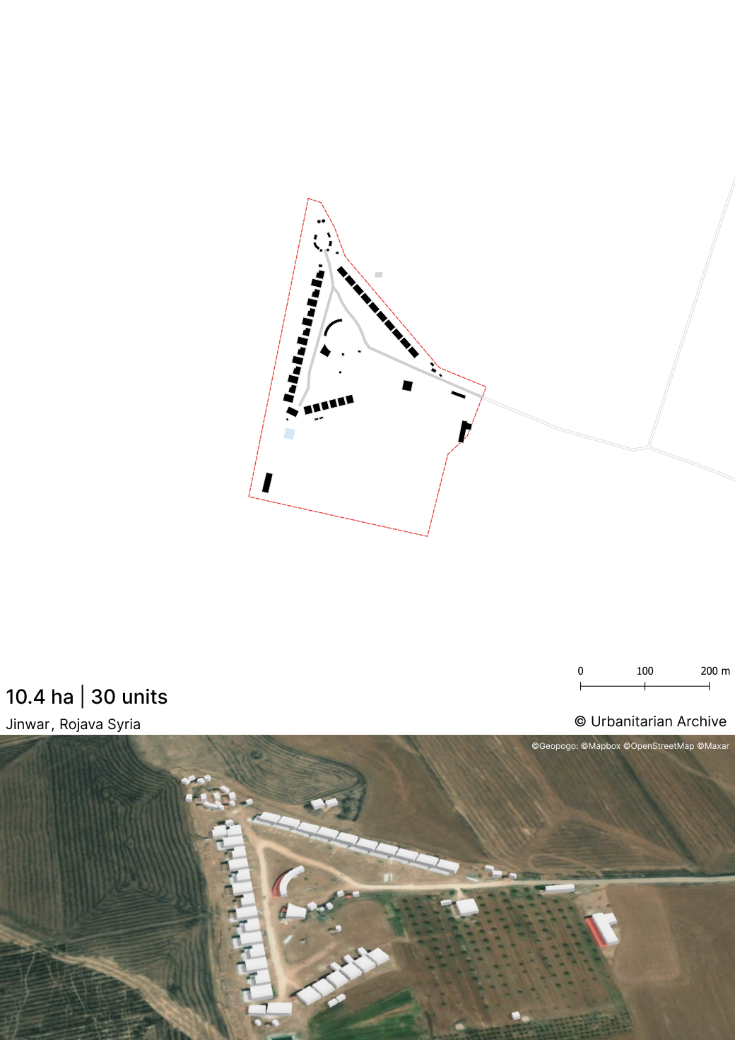
- The settlement consists of small mud-brick buildings arranged in a triangular formation.
- There is a central semi-open community area.
- The community garden that feeds the residents juts into the triangular formation acting as a buffer between the surroundings and the dwellings.
- The village is self-built by the residents using traditional building techniques. They utilize mud brick produced on-site. This cuts costs and reduces dependency on external sources. The mud brick also helps regulate indoor temperature.
- The village houses around 24 families of women and their children in around 50 mud buildings.
- The residents come from various Middle-Eastern backgrounds such as Arab, Kurdish and Assryian . There are also a few women from other regions of the world as well.
- An all-women village committee regularly organizes events and addresses problems faced by the residents.
- The women undertake various ecological agrarian activities such as farming and herding livestock for their daily needs. The various resources and revenue produced within the village are distributed amongst all the residents, leading to a village owned by the community.
- The residents living here follow certain core principles such as ecological awareness and communal economy. The principles aim to achieve self-sufficiency and autonomy for the residents, who are often uneducated or without familial support.
- Important community buildings like the school, health centre and women’s academy are located at the corners of the triangular formation.
- The women’s academy imparts knowledge about “jineology” , self-defence and natural healing practices. Jineology refers to teachings based on the feminist movement led by Kurdish leader Abdullah Öcalan.
- Several amenities such as a children’s park and small pool offer some recreation to the residents.
- A village shop and lodge have also been built.
- A small bakery provides residents with baked bread, operated by two women.
- Overall Layout and Symbolism
- Key Locations and Structures
- The Southern Vertex (Entrance):
- The Northwest Corner (Women's Academy):
- The Opposite Corner (School Area):
- Agricultural and Ecological Integration
- Construction Materials
Women-only Village
Masterplan and Architecture
Inhabitants
Principles
Program
Detail description of the spatial distribution
The physical design and urban masterplan of the Jinwar women's village are deeply intentional, blending practical ecological building techniques with profound symbolic geometry.
The core of the village consists of a residential nucleus of 30 houses arranged to form a triangle. At the orthocentric center of this triangle is a partly uncovered collective space connected by a central plan. The choice of these elementary geometries, specifically the triangle and the circle (or spiral), carries strong symbolic weight. The triangle has been considered a sacred symbol of the Mother Goddess since the Paleolithic era, recalling the generative power of a woman's pelvis.
The layout emphasizes the vertices and axes of the triangle with specific community buildings:
The South features the main entrance with a gate bearing the village's name. Just outside this gate lies the village shop, Dukana Xwa Me. At the entrance on the left is the Academy of Natural Medicine, which is a rectangular building oriented East-West, featuring angles intersected by circular elements and covered by pseudo-domes.
Located on the East-West axis, the Women's Academy is notable for being the only two-story building in the built-up area. Behind the Academy is a water collection tank that doubles as a swimming pool.
The school for the youngest residents is situated opposite the Academy. The school buildings are designed with circular or elliptical plans to facilitate direct eye contact among everyone during lessons.
The area outside the central triangle is dedicated to crops and a garden, acting as a filter between the village's interior and the outside world. The village paths are lined with planted trees, and the masterplan includes spaces for animal husbandry, with a chicken coop and stables located near the Academy's water tank.
The village is self-built utilizing a thousand-year-old Mesopotamian building technology: raw earth, mudbrick, straw, and earth plaster. These site-specific materials were chosen because they provide optimal environmental comfort during cold winters and dry summers. Furthermore, relying on these local natural resources allows the community to bypass the heavy regional embargo, save money, and actively preserve the local ecosystem.
-
https://www.washingtoninstitute.org/policy-analysis/jinwar-womens-village-carving-progressive-enclave-amid-syrias-civil-war
-
https://www.youtube.com/watch?v=hL5CWH6_gD0
-
https://www.researchgate.net/publication/337534357_Jinwar_the_Place_of_Women_as_a_Revolutionary_Practice
-
https://jineoloji.eu/en/2022/02/16/jinwar-womens-village-newsletter/
-
https://jinwar.net/about-us/