Guangming Hub TOD
By
FOSTER + PARTNERS
In
Shenzhen,
China
No collection found
Are you sure?
This will unsave the project your collection.
Compare
Compare this project with others
Details
Views:
1808
Tags
Data Info
Author
FOSTER + PARTNERS
City
Shenzhen
Country
China
Year
2020
Program
Transit Oriented Development
Technical Info
Site area
1405024 sqm
Gfa
0
sqm
Density
0 far
Population density
0
inh/ha
Home Units:
0
Jobs
0
Streetsroad:
0
%
Buildup:
0
%
NonBuild-up:
0 %
Residential
0 %
Business
0
%
Commercial
0
%
Civic
0
%
Description
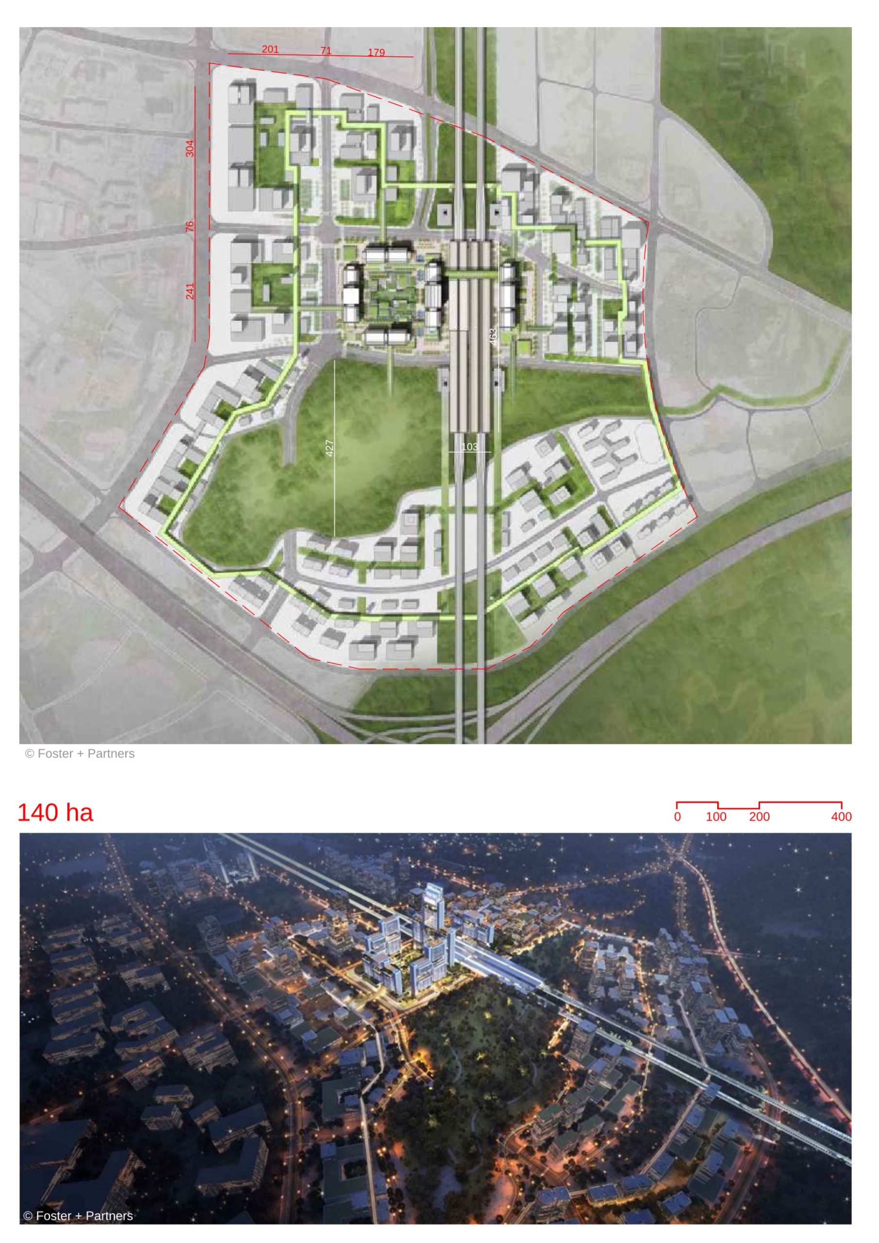
- contemporary urban centre with an integrated and sustainable transport hub at its heart.High-speed rail station is centrally located, oriented in the north-south direction.
- A sunken green spine runs east-west, cutting across the site and through the high-speed rail station at ground level.
- New metro station is situated to the west of the high-speed rail station, straddling the green spine.
- Intercity link station is located further west, near the site’s edge, connecting the Guangming Hub to the city.
- Easy wayfinding, minimum walking distances, and shaded walkways.
- Subways and bridges connect neighboring plots, offering convenience for pedestrians, cyclists, and autonomous vehicles.
- Large retail podium located atop the underground metro and intercity link stations.
- Stepped green terraces from the retail podium integrate with the surrounding forest and offer views of the green spine.
- Office towers are positioned at cardinal points across the site, inspired by traditional Chinese gateways.
- Tower openings at the ground level provide access to the central high-speed rail station.
- A new transport museum is situated on a bridge over the high-speed rail station, connecting the eastern and western halves of the site.
- Futuristic transport museum features immersive exhibition displays using VR, AR, and projection mapping technologies.
- Panoramic views of the high-speed rail station enhance the museum experience.
- Landscape areas, public amenities, and pedestrian-friendly designs contribute to an enjoyable outdoor experience.
- The project incorporates controlled wind and solar access.
- Maximisation of landscape areas and public spaces.
- Design follows the city's Sponge City programme.
- Use of permeable pavement and bio-retention water features ensures effective water management.
- The area is planned as a forested gateway into Shenzhen, with a landscape design that complements the natural surroundings in and around the site.
- A green spine crosses the site from East to West, intersecting with the North-South high-speed railway station.
- The plan is future-ready, anticipating upcoming innovations in transport, such as autonomous vehicles, while ensuring that wayfinding and minimum walking distances prioritize human mobility.
Transit-Oriented Development
Land Use & Architecture
Visitor & User Experience
Sustainability & Environmental Features
Landscape Design and Green Spaces
Future-Ready Transport and Mobility
Location map
Explore more Masterplans