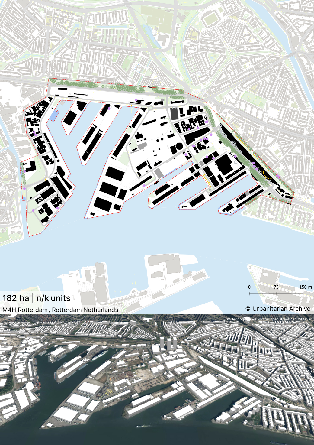
M4H Rotterdam
By
DELVA LANDSCAPE ARCHITECTS / URBANISM
In
Rotterdam,
The Netherlands
No collection found
Are you sure?
This will unsave the project your collection.
Compare
Compare this project with others
Details
Views:
601
Tags
Data Info
Author
DELVA LANDSCAPE ARCHITECTS / URBANISM
City
Rotterdam
Country
The Netherlands
Year
2019
Program
Harbour Redevelopment
Technical Info
Site area
1828446 sqm
Gfa
0
sqm
Density
0 far
Population density
0
inh/ha
Home Units:
0
Jobs
0
Streetsroad:
0
%
Buildup:
0
%
NonBuild-up:
0 %
Residential
0 %
Business
0
%
Commercial
0
%
Civic
0
%
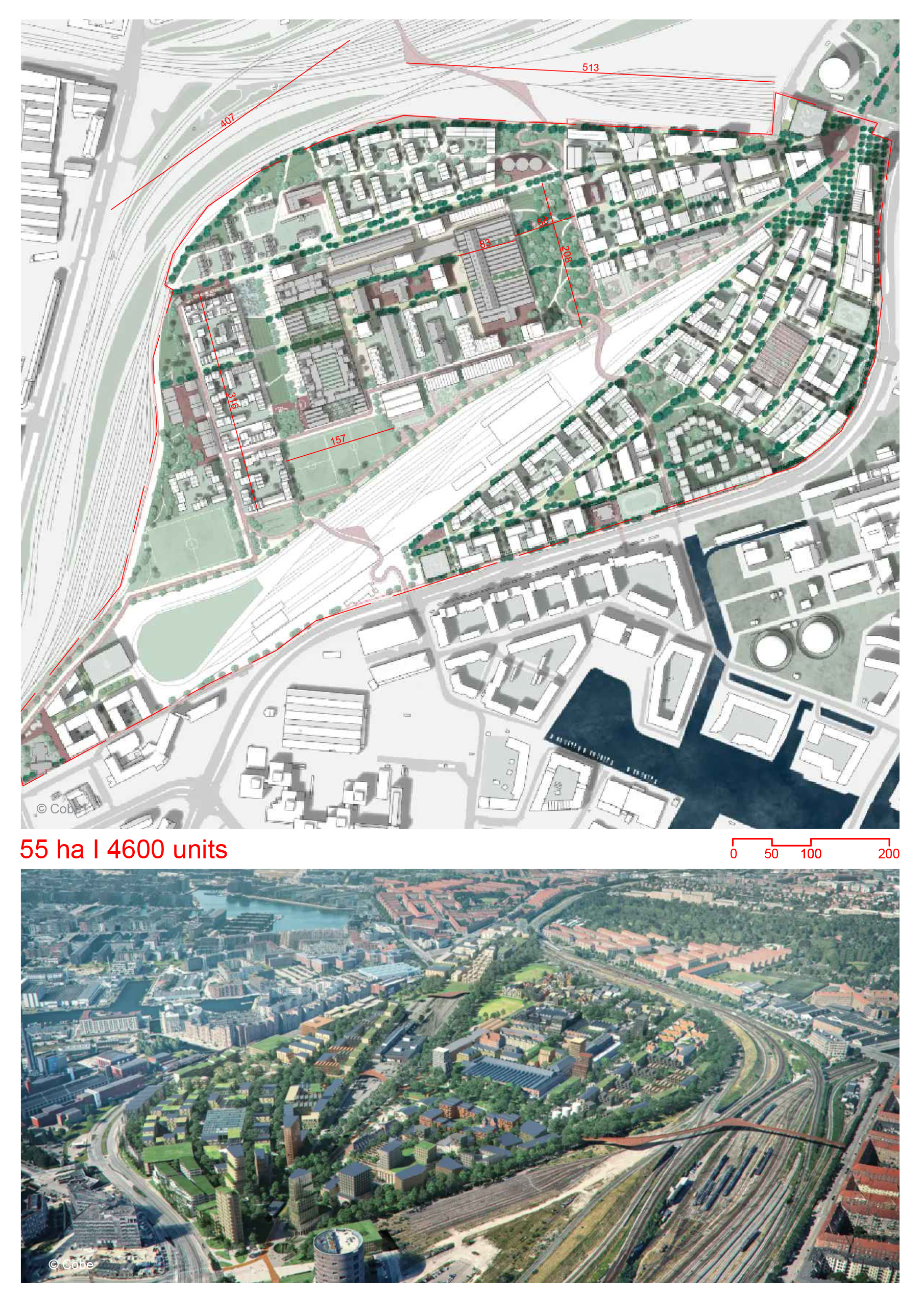
Description
- It is a mixed-use urban district with a focus on innovative manufacturing.
- The district is conceptualised as an interface between city and port.
- It is a port region that is part of a urban renewal project.
- The district is being conceptualised as a maker’s district with facilities like incubators and workspaces as well as prototyping and production areas.
- The district is divided into 5 main districts each planned with a mix of uses.
- The heart of the district is formed by Galilei District. It would be home to large manufacturing companies. It would have other uses such as education, sports and culture but not residential.
- Surrounding the centre would be 3 live-work districts with areas for creative and craft manufacturing.
- There would also be a primarily residential district with small and light manufacturing companies.
- There would be smart transport systems such as water transport.
- The vehicular and soft traffic would be separated.
- There is no street parking. There would be mobility hubs instead. The mobility hubs have collective parking facilities.
- There are two main streets running across the district. Their intersection is marked by two important public buildings.
- The Maker’s Street is a maker’s district corridor with areas for loading, bicycling paths and vehicular road. It is flanked by courtyards of the plots along its length.
- Havenalee is another main street running along the existing dike. It would have shared facilities for the residents.
- Harbor Streets consists of linear roads extend from the dike towards the water along the piers. They form the main road structure for the district.
- The existing variation in building volumes of the industries has been retained to offer a programmatic mix of different tenants. The buildings would have a maximum height of 40m.
- There would be flexible plinths with a minimum clear height of 6m in the work and live-work districts.
- The basic blocks are defined by the quays and basins on either side of the pier streets.
- The basic block is developed as a kit of parts. It consists of a central green space which can be used for experimentation in production or for recreation. There are collective open spaces for loading/unloading. There is also a hub which has collective parking and services.
- The network of green spaces consists of squares, fields, basins and Kopparks.
- The squares are public areas surrounded by active plinths. The fields are multi-purpose open green spaces. They act as extensions of the dike park.
- Kopparks are located the tip of the existing piers. They are collective spaces and act as public parks.
- Basins are designed as tidal parks. The adjacent quays would have varied function, The working quays would provide areas for port activity. The residential quays would act as outdoor spaces for the residential district.
- The Maker’s Street has been designed with flex zones. These areas can be used for a variety of functions such as loading/unloading, street furniture etc. It is not designed as an avenue. It has alternating green areas with trees.
- The Havenalee has a narrower street profile as it is planned to have less vehicular traffic. It is designed with broad sidewalks and street furniture.
Land Use
Mobility
Industry
Urban Structure
Creation of Public Spaces
Location map
Explore more Masterplans