Lisbjerg
By
LENDAGER
In
Aarhus,
Denmark
No collection found
Are you sure?
This will unsave the project your collection.
Compare
Compare this project with others
Details
Views:
662
Tags
Data Info
Author
LENDAGER
City
Aarhus
Country
Denmark
Year
2022
Program
Sustainable Housing Development
Technical Info
Site area
40000 sqm
Gfa
19000
sqm
Density
0 far
Population density
118
inh/ha
Home Units:
215
Jobs
0
Streetsroad:
0
%
Buildup:
0
%
NonBuild-up:
0 %
Residential
0 %
Business
0
%
Commercial
0
%
Civic
0
%
Description
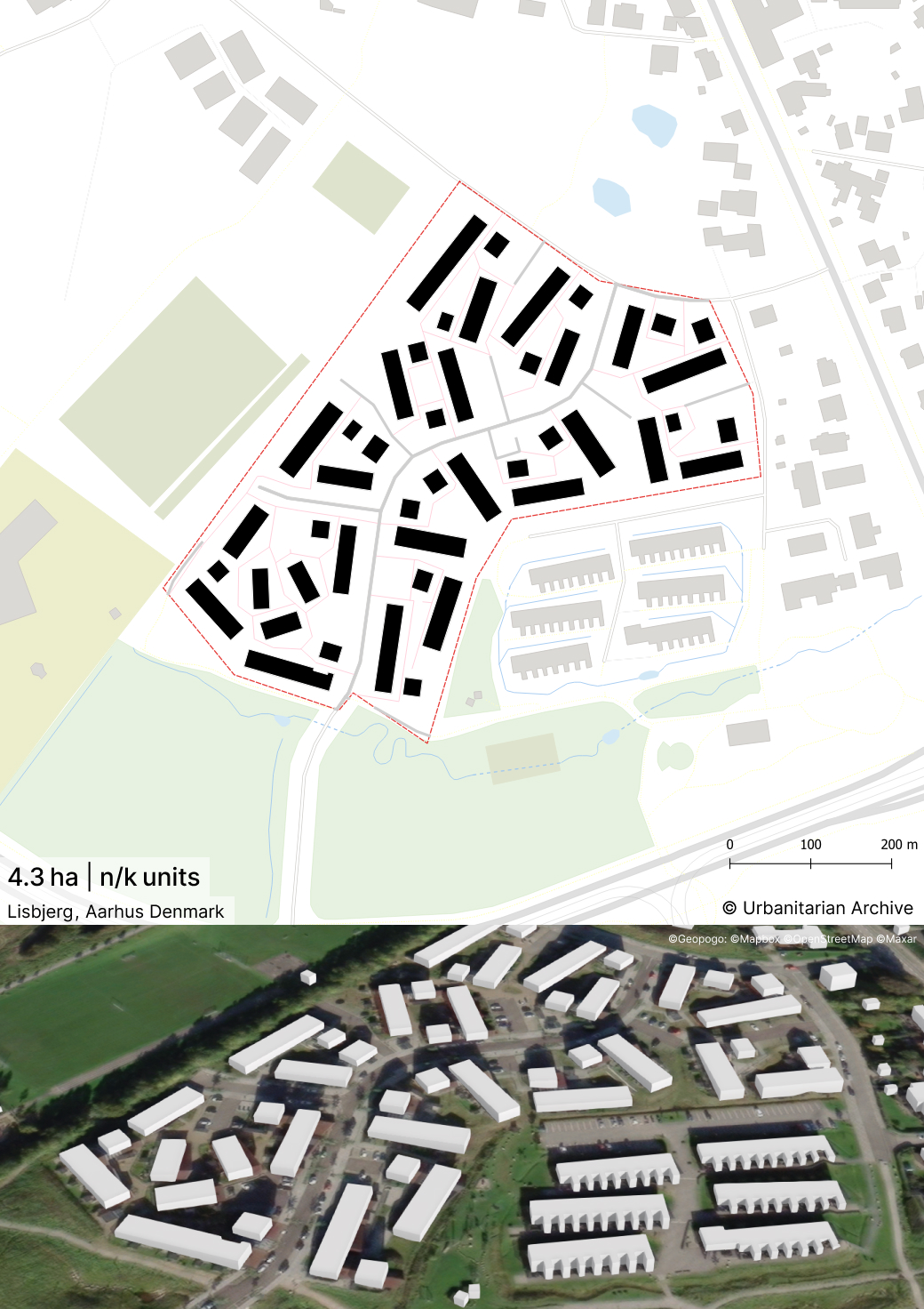
- Lisbjerg is an innovative housing project in Aarhus, Denmark, aiming to be both economically and environmentally sustainable.
- The project prioritizes the use of upcycled materials, with a requirement that at least 20% of facade materials are upcycled. Locally harvested and upcycled wing tiles are also used for facade cladding.
- Economic sustainability is a key aspect of the project, showing that it is possible to build sustainably within social housing budgets, offering affordable housing for students, low-income families, and seniors.
- The design focuses on human scale, encouraging social interaction and the integration of natural elements throughout the project.
- The project is positioned to offer views of the bay and fields.
- The project maintains high occupancy rates despite a challenging market, was constructed within budget, and follows a long-term sustainability strategy.
- The housing units are primarily built using wood and upcycled roof tiles, contributing to a low CO2 footprint of just 7 kg/m² annually.
- The project also includes green features such as:
- 30% upcycled materials, including repurposed roof tiles used as facade elements.
- Natural ventilation systems and solar panels for energy efficiency.
- A district heating system powered by renewable sources.
- Integrated urban farming spaces.
- A 160% bio factor, with fruit trees, diverse vegetation, and green roofs.
- community through spatial clustering and shared outdoor space.
- The project aims for low CO₂ emissions through timber construction.
- Sustainability is extended beyond the buildings into the site design.
- The landscape strategy reduces the need to remove earth from the plot.
- Stones from the site are reused in the landscape.
- Sorted construction waste is used in gabions for retaining walls in the hilly terrain.
- The project combines material circularity, site-sensitive earthworks, and low-carbon structural logic.
- The key idea of the project is to let the neighborhood settle into the landscape instead of imposing a rigid flat-grid logic onto the site.
- The masterplan is structured to work with the sloping topography, reduce unnecessary earth movement, and produce a more varied spatial experience.
- Socially, the project is organized to support small-scale community life rather than anonymous repetitive housing rows.
- The plan is shaped by the idea of a landscape-first community, so terrain is not treated as an obstacle but as the generator of the layout.
- Lendager states that the landscape design was developed to reduce the need for moving earth off the site, which ties the masterplan directly to the existing ground conditions.
- The office also explains that the masterplan aimed to create depth and variation in the spatial experience, while avoiding long parallel lines and working with the sloping topography.
- This means the structure is not simply formal - it is a response to terrain, community formation, and spatial diversity.
- The homes are organized in clusters rather than in one continuous housing field.
- Each cluster consists of two opposite L-shaped building forms.
- This structure creates an open but clearly defined common space between the buildings.
- The cluster logic helps break down the overall scale of 215 homes into smaller neighborhood units.
- The most important spatial move is the creation of semi-defined shared outdoor rooms between housing clusters.
- Instead of endless parallel bars, the layout produces angled relationships, changing views, and varied outdoor conditions.
- The project uses the terrain to produce a varied building-scape, with changing relationships between homes, open spaces, and views.
- The result is a residential environment with more depth, sequence, and variation than a standard repetitive housing plan.
- The urban layout was developed with a stated emphasis on creating a well-functioning local community.
- Shared space is not residual leftover area - it is spatially framed by the housing clusters.
- The organization into smaller clusters supports local meeting, interaction, and neighborly identity.
- The project suggests a model where community is built not only through program, but through the geometry of shared space.
- The homes offer varying degrees of privacy depending on their location in the landscape.
- Different positions in the site create different housing conditions and outdoor-space relationships.
- This means the masterplan does not treat all units as identical repetitions, but uses topography and placement to create a range of residential experiences.
- The landscape is a central ordering device of the project.
- The hilly terrain helps generate different views in all directions.
- Trees, vegetation, and landscape elements are placed in relation to the buildings so that seasonality and natural cycles become part of everyday life.
- The project reads less like housing placed on a site, and more like housing woven into a terrain condition.
- The load-bearing structures are made of wood elements.
- The facade cladding includes reusable and upcycled materials such as:
- brick
- slate
- painted metal sheets
- wooden cassettes
- Lendager positions the project as an example of circular construction at scale.
- The project avoids the typical housing-estate problem of long repetitive rows.
- Its strongest spatial quality is the combination of:
- clustered housing
- defined shared commons
- topographic variation
- changing privacy levels
- multiple views
- The use of opposite L-shapes is especially interesting because it creates spaces that are neither fully closed courtyards nor fully open leftover landscapes.
- This in-between condition gives the open spaces both definition and openness.
- Work with the terrain instead of erasing it.
- Use building geometry to produce social space, not only unit count.
- Avoid monotony by breaking up long housing bars.
- Create residential identity through small clusters rather than only large-site zoning.
- Let landscape perform multiple roles at once - ecological, spatial, social, and technical.
- Estimated population density: 113-129 inh/ha
- Assumption: 2.1-2.4 persons per dwelling based on Denmark average and likely family-oriented housing mix in Lisbjerg.
Vision
Master Plan
Sustainable Features
Core Design Idea
Why the Masterplan Is Structured This Way
Urban Structure
Spatial Logic
Community Structure
Housing and Privacy
Relation to Landscape
Material and Construction Strategy
What Is Most Interesting Spatially
Urban Design Lessons
Location map
Interactive Map
This project includes an interactive map generated from GIS data, so you can study the masterplan as switchable layers instead of a single static image. Use the layer panel and legend to toggle buildings, green areas, water, streets, paths, site boundary, and trees to isolate specific systems and understand how they connect. You can also measure and change the basemap (light/dark/OpenStreetMap) to improve readability while you analyze.
Explore more Masterplans